
Knowing the limits of your land plot is essential when organizing any building or remodeling project. These lines indicate the bounds of your property legally, defining where you are allowed to plant, build, and make changes. The process of determining these boundaries is methodical and involves both physical surveying and legal documentation.
First of all, examining official records like land surveys or property deeds is usually the first step in determining a property’s boundaries. The boundaries of the property are first described legally in these documents, as they were recorded at the time of purchase or subdivision. Although they offer valuable beginning points, they might need to be verified using more exact techniques.
The process of physically surveying an area is essential to precisely identifying its boundaries. Using cutting-edge instruments and methods, certified surveyors precisely measure and plot the coordinates of the land. By going through this procedure, it is made sure that the boundaries are up to code and resilient enough to hold up in court and during construction.
In the course of surveying, surveyors locate and label physical boundary markers. These markers may be physical barriers erected or approved by law enforcement, such as stone monuments or iron pins. In order to verify the surveyed boundaries and avoid property line disputes, these markers act as concrete references.
A thorough survey report is created from the data gathered after the boundaries are marked and surveyed. Precise measurements, boundary coordinates, and any pertinent notes or observations made throughout the surveying process are all included in this report. It functions as an official document that developers, property owners, and law enforcement agencies can consult.
| Step | Description |
| 1. Initial Survey | A surveyor visits the site to gather information about the land. |
| 2. Legal Research | Check property records and legal documents to determine official boundaries. |
| 3. Physical Marking | Place markers on the land to show boundary lines based on the survey and legal research. |
| 4. Verification | Confirm that the markers are correctly placed and match legal descriptions. |
| 5. Documentation | Create a formal report with maps and descriptions of the boundaries. |
| 6. Approval | Submit the report to local authorities for approval and official recording. |
- Regulations and Land Code
- When to Set Boundaries?
- Approval based on actual use
- Methods and procedure for determining the location of an allotment
- Establishing coordinates by cadastral number
- On the ground
- Procedure
- Measurement
- Boundary survey
- Documents
- By coordinates
- According to the land passport
- Documentation
- Procedure
- How to determine the boundaries of a land plot without land surveying
- Contact a specialist
- Using the Internet
- Coordination with neighbors
- Documentation
- Is it possible to specify only part of an adjacent plot?
- Previously recorded area without defining boundaries
- Objects of artificial origin during land surveying
- Useful video
- Video on the topic
- Determining the boundaries of the site in accordance with the law
- How is a dispute about determining the boundaries of a land plot resolved??
- 🔴 Land management examination // Determination of the boundaries of the land plot
Regulations and Land Code

Law 221-FZ’s Articles 39 and 40 outline the process for drawing boundaries.
Determining the boundaries of land under the management of cadastral engineers through official orders and agreement signing.
As per the Land Code, the process of land surveying determines the boundaries of an allotment, which is then used to create a plan.
Along with a description of its coordinates, the passport includes cartographic images showing the boundaries of the private territory in relation to nearby real estate.
It might be necessary to calculate the territory’s size when extending beyond the boundaries of adjacent plots and where it overlaps with previously registered state lands. The Order of the Ministry of Economy and Development dated 24.eleven.08 g. No. 412 establishes the protocol for coordinating the coordinates of adjacent plots.
Employees of Rosreestr, who record real estate on state records, finalize the demarcation of a plot of land based on the findings of cadastral surveys.
The rectangular boundaries of the allotment points serve as a description of their location, following the guidelines set forth in the Ministry of Economic Development’s Order No. 518, p. 2, dated 17.08.12.
When to Set Boundaries?
When the local authorities receive a request from the property owner to alter the location or define the boundaries of the plot, they must initiate the process of determining the coordinates of the plot and recording them in the cadastral register.
If boundaries were not accurately defined in the past or if Rosreestr does not contain boundary data, then control points must be defined.
Land transactions require the use of land surveying:
- purchase and sale of real estate;
- registration of a lease agreement;
- exchange, donation;
- obtaining documents on the ownership of the plot;
- division of a plot of land;
- consolidation of separate real estate objects or formation of new ones.
Using land for operations is not possible without well-defined boundaries. The owner’s actions regarding his property will all be prohibited by law. It is not possible to register rights to an allotment without a land survey plan.
Points on the ground are determined in compliance with the legal requirements and regulations, as stated in Art. 38.7 221-FZ. When settling cadastral disputes or determining the limits of artificial objects or environmental reserves, determining the accurate coordinates of an allotment is an essential step in the process.
Approval based on actual use
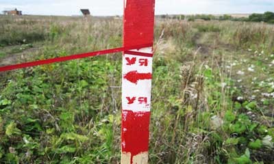
Some neighbors might consent to determine the location’s coordinates without consulting cadastral experts.
All interested owners should be informed of the process and made aware of the conditional boundaries of their allotments in order to establish the size of the territory based on actual use.
The process of drawing the borders around real estate objects comes next, and it looks like this:
- secure the boundaries of the plots using boundary signs, fences or pegs;
- if everyone is satisfied with certain boundaries, the owners should contact a specialized organization and order a boundary plan from an engineer;
- On site, the specialist will fix the coordinates of the plots and enter the information into the documents;
- after the act of determining the coordinates has been endorsed, a land surveying plan is drawn up, indicating the exact limits and dimensions of the site.
According to the sample, real estate owners will only need to provide Rosreestr with the relevant package of documents in order for their property to be state registered.
The boundaries of adjacent plots must be approved by all neighbors before using this survey option. Unauthorized land seizure in other circumstances carries the risk of legal action and high expenses.
Methods and procedure for determining the location of an allotment
You can determine the coordinates of the allotment using a variety of techniques. They are all linked to the work of cadastral experts or autonomous boundary establishment through documentation.
The boundaries of the territory may be "taken out into nature" or established on the ground if they have previously been established but the owner is unaware of them.
Establishing coordinates by cadastral number
Every piece of officially registered real estate has distinct borders, most of which run between neighboring plots.
There are multiple ways to locate real estate objects if you have a cadastral number.
- obtain information from Rosreestr online – rosreestr.ru;
- order an extract from the unified register on the kadastrmap website.ru.
The website’s article on the subject provides more information about defining a land plot’s boundaries based on its cadastral number.
On the ground
Procedure

The plot’s coordinates will need to be determined through land surveying.
Those with interest should get in touch with Rosreestr:
- to write an application;
- attach land title certificates to the request;
- pay the mandatory fee (the amount of payment depends on the area of the plot, characteristics).
Land surveying is needed in order to receive this service.
The engineer will provide a conclusion at the end of the process, which is given to Rosreestr electronically and given to the property owner on paper.
Employees of a geodetic organization use GPS equipment and satellite imagery to conduct land surveys.
Measurement
The plot of land will be measured piece by piece:
- temporary fences and stakes are installed;
- lines are drawn between the limiters, deviations are permissible – 20 cm (the surveyor is responsible for the correctness of the boundaries);
- coordinates on the ground and plan are checked.
The property owner or a representative acting on their behalf may be the works’ client. The existence of a
- surveyor,
- cadastral specialist
- and the owner of the land plot is required for measurements.
Verify that the organization has a current cadastral works license before surveying the plot.
Boundary survey
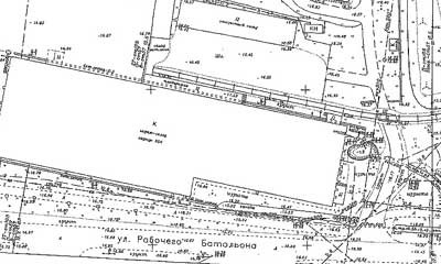
Topographic survey: a map-diagram of the plot that is provided to the client in accordance with the surveying procedure’s findings.
1:1 200 or 1:1 500 is the plan scale.
The land plot’s area and boundaries are shown on the map.
The form of the diagram may alter based on the details of the topographic survey application (provided that this does not conflict with any regulatory laws).
Documents
Original and duplicate copies of the following documents are submitted to mark the plot’s boundaries on the ground:
- passport of a citizen of the Russian Federation of the owner of the land plot (the representative will need to provide a power of attorney certified by a notary);
- document on the form of title to the plot from Rosreestr;
- object number according to the cadastre (if available);
- when allocating part of the plot, an agreement on allotment and the consent of all owners will be required.
In cases where the cadastral number and certificate are absent, the request ought to specify that the land plot must be registered with the state after the land surveying process is finished.
If there are multiple owners, all interested parties’ documents must be submitted.
The engineer creates an allocation plan and indicates its configuration between the red line based on the findings of the topographic survey. The land surveying scheme should be familiarized to all interested parties. When the owners of the adjacent plots agree on the points of the land plot, the cadastral specialist provides a plan for signature that reflects this.
By coordinates
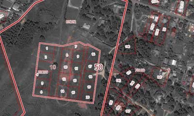
The engineer entering the object data into Rosreestr must clarify the dimensions of the land plot based on the survey results.
There should be no discrepancies between the boundaries on the cadastral plan and the points on the ground if all of the calculations have been done correctly.
Identifying borders entails locating each entity’s territory on a map.
The engineer’s primary responsibility is to carry out this process.
Emphasize various approaches for choosing land plot coordinates:
- If land surveying has not been carried out, the boundaries of the allotment are checked using established signs. The procedure will require the consent of the owners of neighboring properties. Based on the survey results, the boundaries of the allotment are agreed upon with all interested parties.
- If land surveying has been completed, all data is available in Rosreestr. Determination of site boundaries on the ground is carried out on the basis of cadastral data.
See the feature article for information on how to use available coordinates to search for a site in the Rosreestr database.
Controversial issues between the owners of adjacent real estate properties are not resolved by any of the coordinate land surveying options.
In order to prevent this, coordination with all interested parties is required, as determined by the work’s outcomes.
According to the land passport
Documentation
In order to acquire details about a land plot, a few documents will be needed.
Included in the list of documents required to determine the allocation’s coordinates are:
- identification;
- document on the right of ownership of the plot;
- appeal to the UGRCC;
- photocopy of the cadastral passport;
- an act of agreement between the owners of adjacent plots (or a judge’s decision);
- technical documentation for the property, endorsed by the city administration;
- information from the technical plan and a photocopy of the allotment diagram;
- request to UFSGR.
Procedure
The process of pinpointing a land plot’s location using the cadastral plan is done step-by-step.
The action’s algorithm is very straightforward:
- submitting an application to the UGRCC;
- obtaining from the administration a photocopy of the cadastral diagram of the district land plot (the cadastral engineer will need it);
- gathering of all owners of adjacent plots;
- drawing up an approval act;
- certification of the collected package of documents by the administration;
- appeal to the Arbitration Court in case of refusal to sign the act;
- submission of the court ruling to the UGRCC;
- assigning a vehicle registration number and issuing a registration certificate;
- contacting the Federal State Registration Service with a photocopy of the plan, an extract from the certificates received.
Within the 30-day legal window, the owner will be able to obtain a formalized certificate of ownership of the property if all the necessary paperwork is in order.
How to determine the boundaries of a land plot without land surveying
A plot of land can have its coordinates established in a number of ways, including by using an engineer’s services, using the Internet, or coordinating your plot with your neighbors.
Contact a specialist
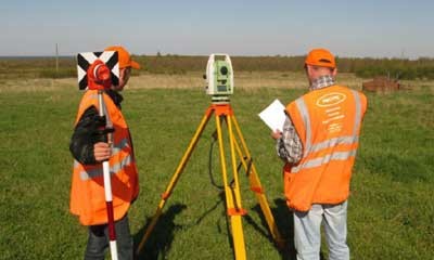
The engineer’s services will cost you money, but the outcome will be more precise. Setting limits with it necessitated:
- submit a request to the chamber at the address of the property;
- the engineer, based on the documentation received from the cadastre, will demarcate and mark the points;
- the boundaries of the allotment are marked with pegs (permissible discrepancy 20 cm).
Land surveying can only be done by companies that are legally authorized to perform this kind of work.
Using the Internet
Information about the land plot will be available on Rosreestr’s official website if it is registered. You must visit the institution’s portal, complete the necessary fields, and submit a data request in order to get information.
See our separate article for more information about this process.
Coordination with neighbors
The permission of the owners of adjacent plots will be needed to establish the limits of the allotment.
To complete the necessary procedure:
- call a meeting (send out written notices);
- invite surveyors for land surveying;
- draw up an approval act.
The endorsement of documentation by all parties involved is required. The process of establishing coordinates will only be legitimate in this manner.
Documentation
Law 221-FZ, 7.8 tbsp. 38, states that points and coordinates are used to define a land plot’s boundaries. Documentation related to titles can provide information.

If they are absent, the information can be easily verified with documents that show where the allotment where they are designated is located:
- registration certificate;
- agreement of purchase and sale, exchange;
- deed of gift;
- evidence.
The boundaries of the site will be objects that have been there for more than 15 years if there is no evidence.
In building and remodeling projects, figuring out a land plot’s boundaries is an essential step. Accurately determining a property’s boundaries requires a number of procedures to ensure legal compliance and support appropriate development planning. Property owners and developers can create defined boundaries by using surveying methods and reviewing legal documents. This is necessary to get permits, keep neighbors happy, and make the best use of available land. By being aware of this process, one can minimize potential conflicts over land use and ensure that construction and renovation projects go smoothly while adhering to regulatory requirements.
Is it possible to specify only part of an adjacent plot?
The number of approval certificates must match the number of designated real estate objects, as determined by the outcomes of cadastral surveys that determine the size of multiple land plots.
On the basis of h. 2 tbsp. 43 221-FZ separate act, no approval is necessary if, at the conclusion of the procedure, only a portion of the boundaries of the adjacent allotment, coinciding with the interior of the site – the object of work.
When addressing errors in Rosreestr concerning the border’s location next to the identified property—the work object—such norms are also accurate.
You will need to submit an additional request and attach a different approval document to the boundary plan if errors are found in coordinates that are not close to the area being examined.
Previously recorded area without defining boundaries
Sites not listed in the state real estate register that were registered prior to March 1, 2008. The boundaries and area of previously recorded plots are not available. When land surveying is done, the land is shown in the cadastre without any boundary markings. Engineers are needed in order to coordinate the boundaries of such land plots.
You will need to specify and approve this data if there are documents for previously registered plots but the cadastre contains no information about them.
The owner must submit a request to the chamber, which will then make the necessary adjustments.
Objects of artificial origin during land surveying
Part 9 of Art. 38 221-FZ states that the information in the title documentation is used to determine the location of a plot of land’s boundaries.
The boundaries of the allotment are established by using artificially created objects, such as private households and capital structures that have been in place for more than 15 years, in the absence of supporting data. Boundaries can also be made clear by using natural "structures."
Useful video
Watch this fascinating video to learn how a land plot’s boundaries are established.
Establishing a land plot’s boundaries is an essential first step in land ownership and development. It guarantees legal certainty and clarity for all stakeholders, including developers and homeowners. Determining the exact boundaries of a property guarantees that any construction or renovation project complies with local regulations and helps prevent conflicts with neighbors.
Typically, the procedure entails hiring a qualified surveyor who will precisely measure and map the land using specialized equipment. The precise boundaries of the property will be marked on a map and in-depth report that this surveyor will produce. For a number of legal and financial transactions, such as purchasing or selling real estate, getting building permits, and getting loans, these records are necessary.
Determining boundaries accurately is also essential for urban planning and environmental preservation. Municipalities can better oversee zoning regulations, infrastructure development, and environmental protection initiatives by establishing clear boundaries for their territories. Conversely, property owners are able to maximize the value and utility of their land while abiding by the law by making well-informed decisions about how to use it.
In conclusion, defining a land plot’s boundaries is an essential part of managing and developing a property. It gives property owners and authorities alike legal clarity, avoids conflicts, and supports well-informed decision-making. An accurate land survey is an essential tool whether you are planning a construction project, buying new land, or just trying to figure out what the boundaries of your property are.


