
Comprehending the intricacies of land surveying is imperative when handling real estate. Of all the survey types, geodetic surveys are essential for accurately measuring and delineating a land plot’s boundaries. Whereas cadastral surveys concentrate on the legal aspects of property ownership, geodetic surveys use cutting-edge surveying techniques to ensure precise spatial positioning.
To determine the precise coordinates and elevations of locations on the surface of the Earth, geodetic surveys make use of advanced equipment and techniques. In order to ensure that all measurements are carefully recorded and validated, this data is crucial for infrastructure planning, property development, and construction projects.
A crucial differentiation between geodetic and tacheometric surveys is found in their respective methodologies. While geodetic surveys combine satellite technology and global positioning systems (GPS) to achieve unmatched mapping and positioning accuracy, tacheometry entails precise measurements using optical instruments.
Undertaking a geodetic survey ensures accurate data that meets global standards for property owners and developers. This type of survey provides detailed spatial data that is necessary for legal documentation, urban planning, and environmental assessments, going beyond simple boundary marking.
- Types of location surveys
- Geodetic
- Cadastral
- Tacheometric
- Control executive
- Video on the topic
- Cadastral survey in the Leningrad region
- Basics of GPS Field Surveying
- Why do you need topographic survey and geodesy??
- Topographic survey of the site. The order of work in Simple Geodesy.
- Clarification of the boundaries of the land plot. Why is it necessary?? Clarification procedure. "The engineering geodesy"
- SIZE OF LAND ACCORDING TO USRN. INVERSE GEODETIC PROBLEM length of sides of a site according to coordinates
Types of location surveys
Every kind of site survey has different objectives and varying degrees of plan complexity. The technical documentation’s complexity affects the final cost of the documents as well.
There are differences between the following types of filming:
- Geodetic. Collection of information about the site for drawing up a technical plan for construction, conducting communications, laying roads, etc.d. The main task of a surveyor when working is to determine the landscape features of the selected area. The result of the work is a terrain plan on paper or electronic media with the location of physical objects.
- Cadastral. Surveying is ordered if it is necessary to establish the legal right to ownership of the site. The main goal is to designate the boundaries of the site and coordinate them with the owners of neighboring territories. Upon completion of the work, they expect the territory to be surveyed and assigned a cadastral number in the Unified State Register.
- Tacheometric. The main type of survey of undeveloped or sparsely developed territories. When carrying out work, not only the planned but also the altitude location of objects is indicated. The final plan displays a vertical section of the terrain. Necessary to study the relief of a small area, for example, determining the maximum and minimum height.
Geodetic
Determining heights and setting coordinates in accordance with federal maps of the region is the primary goal of a geodetic survey.
A geodetic survey of a plot of land is typically broken down into three main phases:
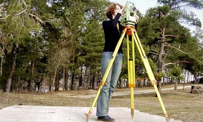
- Preparatory work. At this stage, the engineer must obtain permission for measurement work and surveying of the site. Preliminary work includes collecting information and studying the object based on documentation and an initial inspection of the territory.
- Field work. An important stage during which measurements are taken in open areas using special measuring instruments.All work is carried out in strict accordance with regulatory documents.
- Office work. Analysis and processing of collected materials to draw up a site plan.
Cadastral
The purpose of a cadastral survey was to determine a plot of land’s boundaries. Essentially, it is a condensed form of a horizontal site plan created by geodetic surveying.
Working with the corresponding documentation is the primary task involved in creating a cadastral plan.
Traditionally, the stages of surveying are as follows:
- Request for information about the site from the national cadastre on property rights, initial geodata;
- Collecting contact information of owners of adjacent territories and notifying them in writing about the upcoming approval meeting with an exact indication of the date, time and location;
- Geodetic survey, determination of boundaries and area of the site;
- Coordination with the owners of adjacent plots and drawing up minutes of the meeting. Collection of signatures on no objections;
- Drawing up a land management map and completing land surveying.
Tacheometric
The maintenance of land and city cadastres, land reclamation projects, settlement planning, etc., all use tacheometric surveys.
Technical theodolites and tacheometers are used to measure and plan this kind of engineering survey.
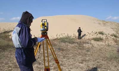
Proceed as follows:
- Determining the position of the point to be removed by pointing the pipe at the staff. The rail is installed at the desired point.
- Determining the polar coordinates of terrain points and plotting them on the plan.
In terms of time, this kind of measurement work is the fastest.
Especially sought after for measuring slender stretches of land along power lines, railroad tracks, and other linear objects.
The primary benefit of this kind of shooting is that it is not reliant on the weather during the survey.
The end product of the work was a plan that was created using a plotting program.
Control executive
Putting the construction project into action and spotting deviations from the plan during construction are the goals of the executive geodetic survey.
In actuality, the coordinates of structures, as well as the separations between them, are established during shooting.
It is feasible to evaluate the contractor’s overall technological compliance and the quality of the construction using the control as-built survey.
There are multiple stages to executive photography, and each one concludes with:
- Current executive shooting. Provides intermediate control of the facility at all stages of construction for subsequent correction of inaccuracies. Allows timely identification and correction of inaccuracies in the installation of load-bearing structures.
- Final executive shooting. Upon completion of all construction tasks, a control as-built survey is carried out using measurements of underground and surface communications.
Thus, the process of creating an executive master plan takes place.
Knowing the differences between geodetic, cadastral, and tacheometric surveys is essential when it comes to land assessment. Accurately charting the Earth’s surface while taking gravity and curvature into account is the main goal of a geodetic survey. It offers exact elevation and boundary coordinates, which are necessary for big projects and legal requirements. Cadastral surveys, on the other hand, highlight legal rights by defining property boundaries for ownership and taxation purposes. Contrarily, tacheometric surveys quickly measure heights, angles, and distances using specialized equipment, making them perfect for in-depth topographic mapping. Every survey type has a specific function that guarantees accurate and lawful land management and development.
| Topic: | What is a geodetic survey of a land plot, its differences from cadastral and tacheometric |
| Description: | A geodetic survey of a land plot involves precise measurement and mapping of its boundaries and features. It ensures accurate property boundaries for legal and construction purposes. Unlike cadastral surveys which focus on legal registration, and tacheometric surveys which use angles and distances for detailed mapping, geodetic surveys emphasize precision and spatial data. |
Precisely defining the boundaries and features of a land plot depends on a geodetic survey. A geodetic survey’s main objective is to determine the exact spatial coordinates and dimensions of the land, in contrast to cadastral and tacheometric surveys, which concentrate on legal registration and precise topographic measurements, respectively. This entails mapping out the plot’s precise contours and features using cutting-edge surveying equipment.
To collect data with a high degree of accuracy during a geodetic survey, specialized instruments like GPS receivers and total stations are used. This information is used to produce intricate maps and plans that are necessary for many different tasks, such as property development, building projects, and urban planning. A geodetic survey makes sure that every physical feature of the land is measured precisely and recorded.
The goals and approaches of geodetic, cadastral, and tacheometric surveys differ significantly from one another. A geodetic survey gives priority to precise spatial positioning and dimensioning of the land, whereas cadastral surveys concentrate on legal boundaries for taxation and land registration, and tacheometric surveys emphasize detailed mapping of terrain and structures. This distinction draws attention to the various uses and specifications of surveying techniques according to the demands of particular projects.
To sum up, a geodetic survey offers crucial information for precise land management and development. It facilitates well-informed decision-making in urban planning, construction, and other development projects by accurately charting the spatial coordinates and features of a land plot. Leveraging its benefits in engineering, architecture, and environmental planning requires an understanding of its function and how it differs from cadastral and tacheometric surveys.


