
Have you ever wondered where the boundaries of your property are? Knowing the limits of your property plot is important for a number of reasons, including legal ownership and the planning of additions or renovations. But not every land plot has precisely defined boundary coordinates. Determining these boundaries can be difficult in some situations, particularly with older properties or rural land.
A land plot without precise boundary coordinates is one without precise measurements or markers denoting its edges. This may occur because of out-of-date records, unavoidable topographical changes, or a dearth of historical records. It takes a combination of techniques and equipment to determine the precise borders of your property in the absence of these coordinates.
Many methods can be used to identify the boundaries of a land plot in the absence of defined coordinates. Using physical markers, like fences or natural landmarks like trees or rivers, or even unofficial markers like nearby structures, is one popular technique. These hints might not provide the precise information required for legal reasons, even though they can offer a broad notion of where your property ends.
A variety of instruments and methods are employed by qualified surveyors to determine boundaries more precisely. With the help of sophisticated surveying tools like GPS units and total stations, surveyors can create boundary lines with extreme accuracy by measuring angles and distances precisely. To confirm borders and settle any disputes, these experts also refer to old maps, court records, and regional land registries.
Legal security and property rights depend on your ability to comprehend and ascertain the boundary coordinates of your land plot. Property owners can make sure they have a clear understanding of the dimensions and boundaries of their land by using both professional surveying techniques and practical observation.
| Issue | Resolution |
| Identifying a land plot without boundary coordinates | Use a GPS device or smartphone app to mark corners and edges, or hire a surveyor for accurate measurements. |
- Boundary coordinates
- A plot without boundary coordinates – what does it mean??
- How boundary points are set
- By possession
- By neighbors
- By cadastral number
- With the help of an engineer
- Going to court
- Errors
- Technical
- Cadastral
- Video on the topic
- How to check whether there is a land survey on a plot of land online. What is land surveying in simple words.
- How to determine the boundaries of a land plot? / MY RIGHTS
- House without boundary coordinates on the cadastral map. What to do? Is it possible to buy?
Boundary coordinates
A land plot’s boundary coordinates are actually a precisely defined indication of where the contour lines that define the plot’s boundaries and set it apart from the surrounding area are located.
It is important to keep in mind that cadastral engineers more frequently utilize the concept of coordinates of boundary turning points when defining "boundary coordinates."
This is because the site’s boundaries themselves serve as lines that are essentially drawn between established strongholds; that is, once the site’s location and boundary are established, the points where one straight line ends and another begins are also established.
Coordinates are therefore the cadastral points that the cadastral engineer determined during the work.
Coordinate determination is a fairly involved process that calls for specialized professional knowledge and, most importantly, the availability of a license for this kind of work.

In other words, the engineer is qualified to perform this kind of work, and the boundary plan he signs will only be enforceable if he is listed among the Russian Federation’s recognized specialists.
Determining the coordinates of turning points or boundaries can only be done after the surveying process is completed, all required steps are taken, and a case is formed, of which the boundary plan is a crucial part.
A plot without boundary coordinates – what does it mean??
The phrase "without boundary coordinates" when referring to a land plot actually indicates that no land surveying process was done for this particular plot, and the boundaries that have been established are merely estimates.
In other words, the turning points that delineate the passing boundary could be inaccurate, necessitating a legal procedure for determination. Such circumstances may occur if the plot is not registered as the owner or if it is on public land (for instance, as a component of a partnership, etc.).
Simultaneously, the absence of coordinates might result from the process employed during the dacha amnesty to establish boundaries based on a streamlined principle. These regions were given cadastral numbers without turning point coordinates, eschewing the legal processes.
Irrespective of who is partially to blame for the infringement, the site owner will bear some of the consequences, including the possibility of fines.
How boundary points are set
The general procedure for drawing a land plot’s boundaries is to gather all relevant documentation, process the information that has been received, perform any necessary computations, visit the location to take measurements, and finally identify the values that will serve as the boundaries’ coordinates.
However, depending on the site’s already-available data or established characteristic indicators of passing boundaries, the methods and principles of determination may vary slightly.
By possession
Determining a site’s boundaries directly along the property’s boundaries is one method of doing so.
Taking into consideration installed pegs, fences, and any other visible and identifiable values with characteristic features, this method actually stays within the drawn boundaries.
The area’s comparable site boundaries are the only thing that should be considered when establishing the passing boundary.
In any case, the necessary computations and coordination of said boundaries with the site owners will accompany the entire complex of actions.
The location and configuration of the boundary will only be included in the boundary plan if it is found that the boundary can be drawn in this manner and that they are lawful.

By neighbors
Even though it might not be the most reliable method, identifying passing boundaries in nearby areas can occasionally be a big help to the cadastral engineer when figuring out coordinates.
In this case, the boundaries of the plots that are next to the site are used as a starting point, given that the plots in question have a compiled cadastral plan, meaning that these are reliable values.
Calculations and measurements taken during a site visit are used to determine other boundaries that are not shared by other plots.
By cadastral number
The cadastral number of the object is the next technique to ascertain the precise coordinates of a plot’s boundaries. You can access the national database and get detailed plot information by providing the object’s cadastral number.
A specialist can rely on such data when determining the precise coordinates of the boundaries, even if the turning points were indicated without following the surveying procedure and going through all the stages necessary in such a case.
With the help of an engineer
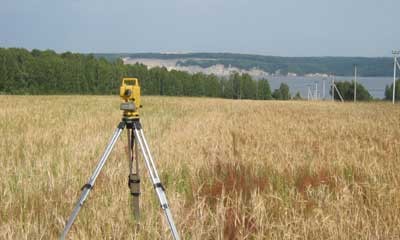
A cadastral engineer determines the values of turning points when there are no additional conditions that allow the precise coordinates of the passing boundaries to be ascertained.
In this case, he makes a request for all the data that is accessible in the region where the site is located directly, performs the required computations, and finds the coordinates.
Then travels to the site location, where modifications can be made while considering the landscape’s characteristics or nearby natural objects.
We address the important problem of determining boundary coordinates for land plots in this article. Many plots have ill-defined borders, which can lead to ownership disputes and legal issues. We’ll explore useful techniques that anyone can apply to precisely identify these boundaries. Every technique, from antiquated maps and historical records to cutting-edge surveying instruments like GPS and laser measurements, is essential to drawing precise boundaries. This knowledge is crucial for anyone involved in land ownership or development, as it not only ensures compliance with legal requirements but also clarifies property ownership when these coordinates are understood and marked correctly.
Going to court
In certain cases, the only recourse available to the owner of a land plot when they are unable to peacefully establish the coordinates of the boundaries—even with the assistance of a cadastral engineer—is to file a lawsuit.
In general, when the owner has the right to file an appeal with the court, the following circumstances might be taken into consideration:
- If, in the process of agreeing on the passing borders with any of the neighbors it was not possible to reach direct agreement. This situation may be due to the fact that one of the owners has a different opinion regarding how the boundary should be laid;
- If boundaries were determined during the land surveying process, and subsequently the owner reconsidered his consent and decided to challenge the existing results;
- If after the establishment of boundaries it turned out that the passing lines were wrong. Such errors may consist of crossing boundaries, overlapping sections and other inaccuracies that arose due to incorrect calculations, incorrectly set boundaries, the use of outdated equipment, etc.d.;
- If the land surveying procedure took place without the participation of the direct owner plot. Such situations are quite rare, but can occur.
In order to resolve a case in court, one must file an application, include all required supporting documentation, schedule a hearing, and then render a decision.
The only factors that will determine the solution are the cadastral engineer’s updated data and supporting evidence.
Errors
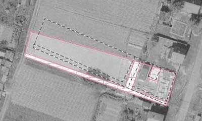
Cadastral errors of various kinds frequently occur during the process of determining the coordinates of land plots; our article goes into further detail about them.
Consequently, these mistakes lead to the requirement that the boundary plan be corrected in one of the methods that are feasible.
Generally speaking, errors in nature can be cadastral or technical.
Technical
The inconsistency between cadastral documentation and the national register (cadastre database) is an example of technical survey error.
When all calculations and measurements are done correctly and the error was made almost at the end of the data entry process, it can actually be expressed as an inaccuracy in the number of boundary points displayed as well as any designations.
Cadastral
More severe inaccuracies are found in cadastral errors.
In actuality, there is no disparity in this case between the cadastral documentation and the national register; however, all sources will contain inaccurate information since the engineer’s coordinates were discovered to be incorrect during the course of information analysis, calculations, and field visits.
Don’t freak out if your land plot’s boundary coordinates aren’t obvious. It’s a typical problem that can be fixed with a little work and the appropriate strategy. This is how you would go about drawing the borders of your land plot.
First, see if there are any surviving records, such as old deeds, surveys, or maps, that pertain to your land. These could hold important details regarding the boundaries. Sometimes useful historical records or insights can also be obtained from nearby property owners or local land registry offices.
If historical records are inadequate or unavailable, physical markers on the ground might be an option. Seek out natural landmarks like trees or rocks, or boundary markers like iron pins or concrete markers. These markers can aid in defining the boundaries of your plot and are usually positioned by surveyors during initial land surveys.
A professional surveyor is highly recommended for precise determination, particularly in complex cases. Surveyors measure and map property boundaries precisely using specialized tools and methods. They are able to produce an official survey report that is legally valid and contains all the information required to determine the boundaries of your land plot.
Recall that understanding the boundaries of your land plot is essential for a number of reasons, such as property rights, court cases, and building projects. By taking the time to ascertain them accurately, you can ensure that you are aware of the boundaries of your property and can prevent future disputes.


